Il Sentiero dei Fortini
Un percorso di rara bellezza tra cornici di roccia e baie dalle acque turchesi
di Ugo Canfora | foto di Vincenzo Gargiulo
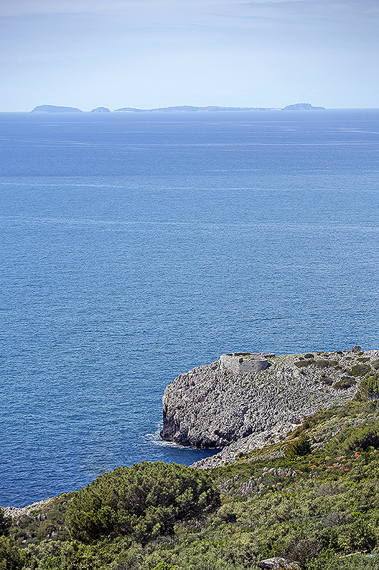
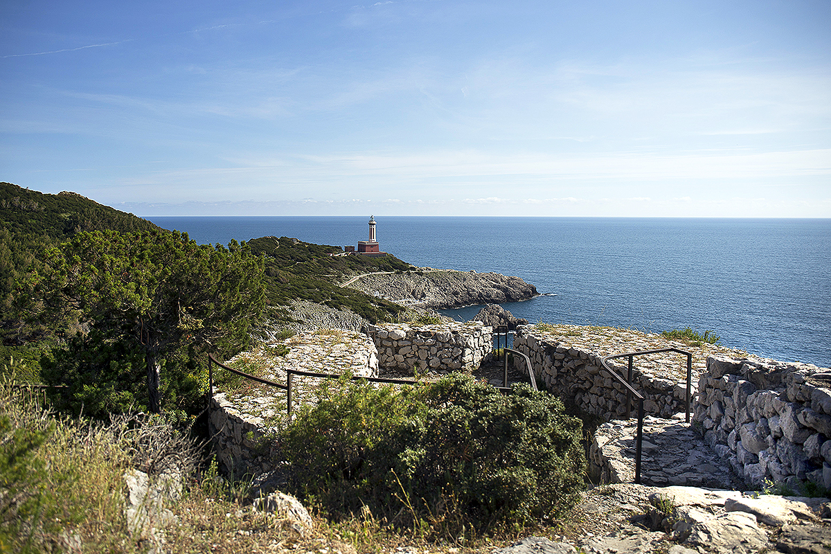
 Lungo la costa occidentale dell’isola, quella di Anacapri, che si staglia severa sul mare aperto a perdita d’occhio, si snoda il Sentiero dei Fortini, uno dei pochi luoghi privo della rassicurante visione della terraferma che invece caratterizza il versante Est. Un itinerario che racchiude e sintetizza l’essenza dell’isola, le sue asperità e le sue dolcezze, attraverso i tre elementi primigeni che la plasmano: il mare azzurro avvolgente e totalizzante, la roccia dolomitica che in pochi chilometri si rivela accogliente ed impietosa allo stesso tempo e il verde della macchia mediterranea che orna le pianure e gli sbalzi.
Elementi primordiali, che come la materia grezza per lo scultore, hanno dato forma e sono divenuti sostanza stessa del mito di Capri, un insignificante scoglio di inaudita bellezza che è diventato ago della bilancia della storia, dai tempi antichi fino ai giorni nostri. Quella storia che ha voluto proprio quelle coste come palcoscenico di alcuni suoi capricci: le fortificazioni di epoca medievale, appunto i Fortini, per secoli hanno vigilato con alterne fortune sulle incursioni saracene, sono stati distrutti, ricostruiti ed ampliati fino a diventare, ai primi dell’Ottocento, il baluardo delle difese delle forze inglesi nel Golfo di Napoli ed il teatro della Presa di Capri da parte dell’esercito francese di Gioacchino Murat.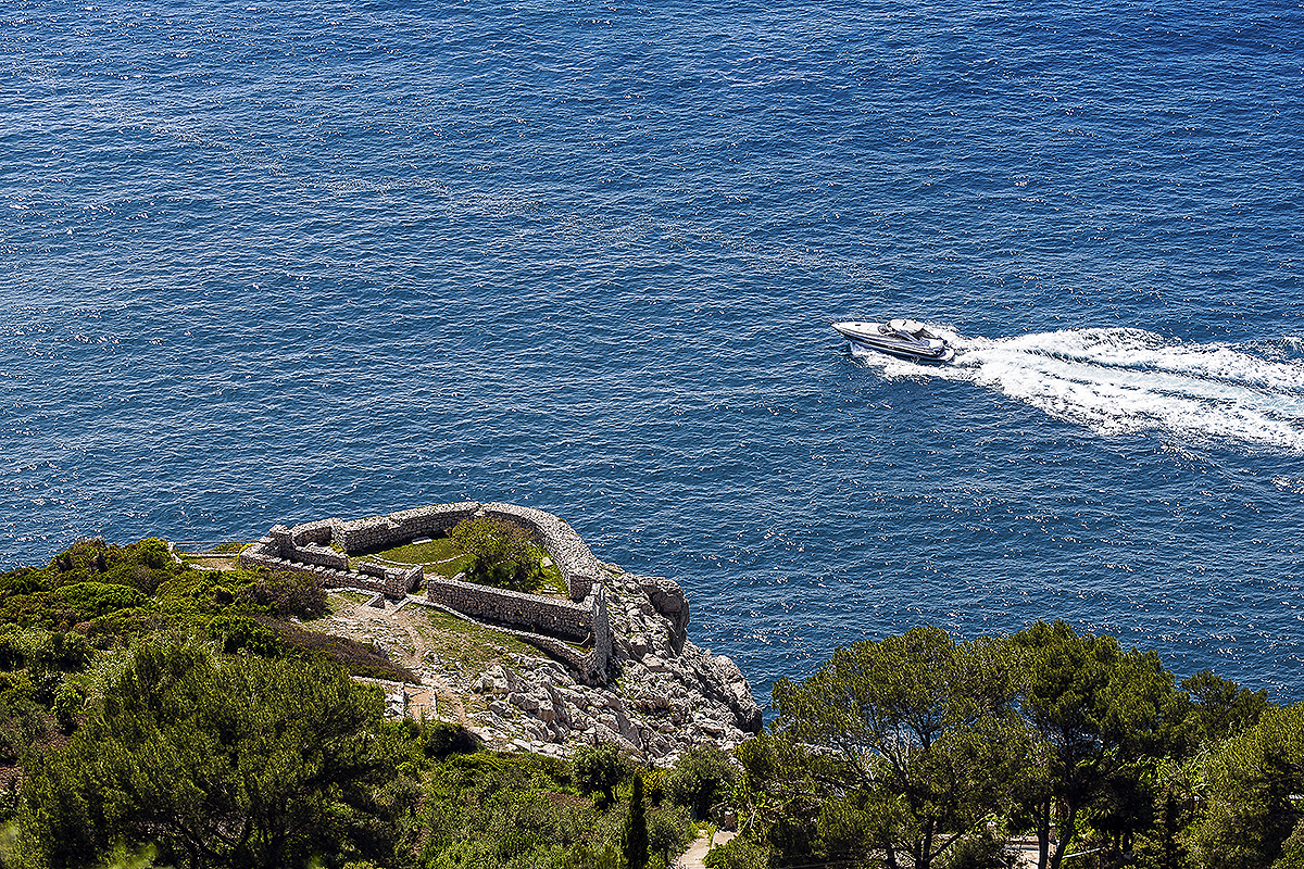
Ma per ogni grande storia esiste una piccola storia: quella sussurrata a chi si avventura tra i sentieri, le rocce, le mura consumate dagli elementi.
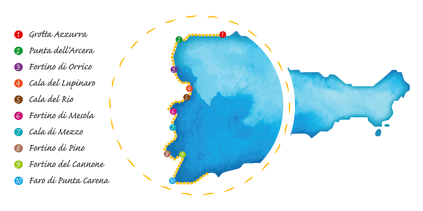
Il percorso ha una durata minima di 3-5 ore e può essere intrapreso da due punti ben precisi, uno sul versante della Grotta Azzurra e l’altro dal Faro di Punta Carena. Se iniziare da quest’ultimo ha un indubbio vantaggio sul piano della comodità, infatti si evitano lunghi tratti in salita, partire dal versante della Grotta offre una sensazione di “crescendo” che culmina con il meritato riposo nella baia del Faro di Punta Carena, dalla quale ammirare il più bel tramonto dell’isola.
Il sentiero non presenta particolari difficoltà ed è affascinante in qualsiasi periodo dell’anno, opportunamente equipaggiati con abbigliamento e calzature idonee e abbondanti scorte d’acqua specialmente d’estate quando le temperature e l’esposizione solare possono diventare problematiche.
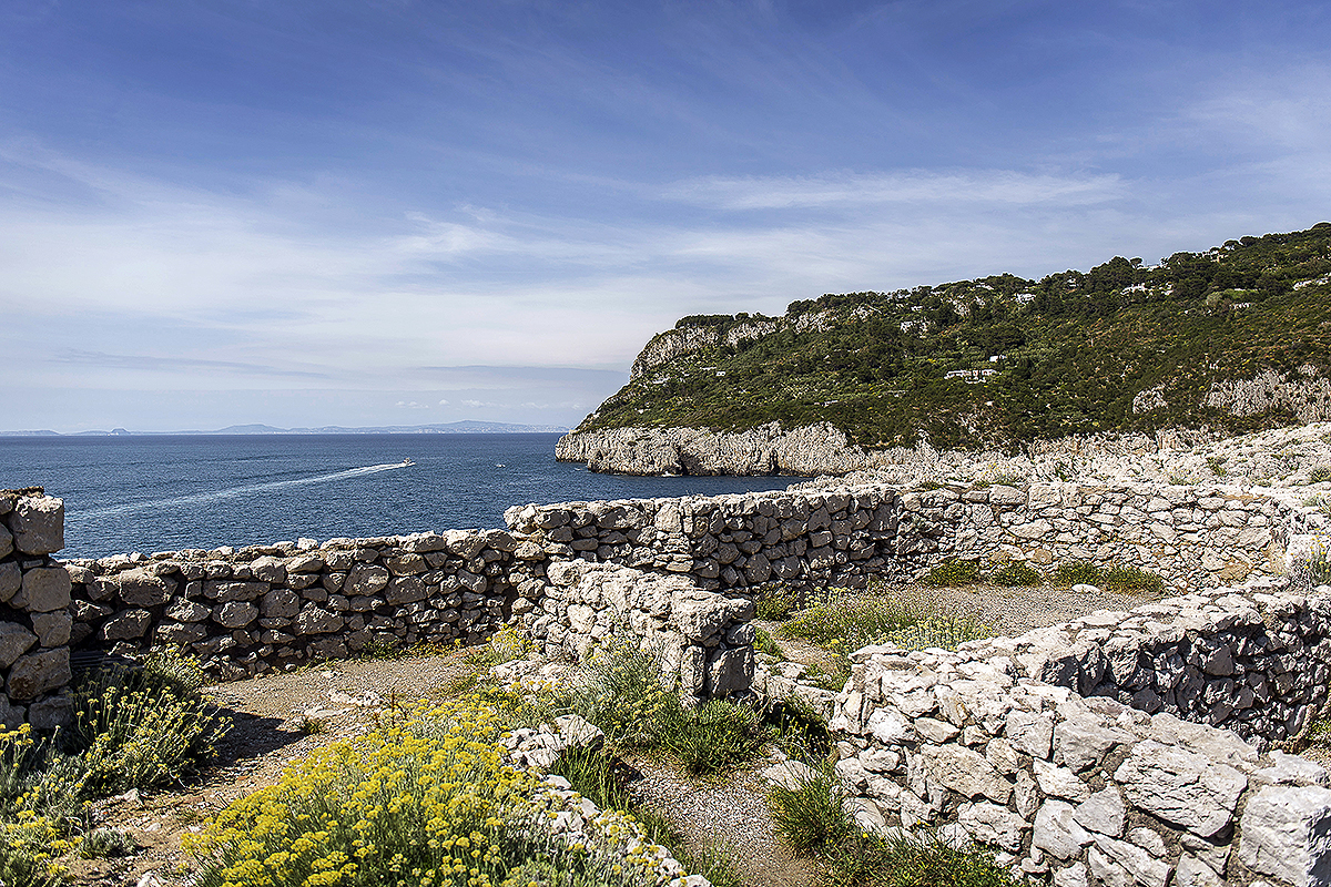
Partendo dall’imbocco del sentiero a poche centinaia di metri dalla Grotta Azzurra, in prossimità della Punta dell’Arcera, dopo un breve tragitto si giunge al Fortino di Orrico, costruito sulla Punta del Miglio. Un tratto di costa a picco sul mare affascinante sia sotto il solleone di agosto sia sferzato dalla tramontana autunnale, che fu il punto di sbarco delle truppe francesi che diede il via alla Presa di Capri. Affacciandosi dalle mura del fortino si può osservare, non senza un pizzico di stupore, la scogliera utilizzata per le operazioni di trasbordo di truppe e materiale logistico. È difficile immaginare un percorso agevole per l’arrampicata, un ulteriore fattore che testimonia come l’operazione dell’esercito di Murat sia da considerarsi un piccolo capolavoro di tattica militare.
Proseguendo nel percorso, costellato di mattonelle illustrative in ceramica con informazioni sulle specie della flora e della fauna che caratterizzano la zona, dopo una deviazione del sentiero che conduce ad una scogliera, la Spiaggia delle Capre, si riprende la strada canonica dove lo scenario cambia nettamente, con un’alternanza di varie zone boscose, finché, superata Cala del Rio, non si scorge in lontananza il secondo fortino, quello di Mesola, che si staglia sulla Punta Campetiello.
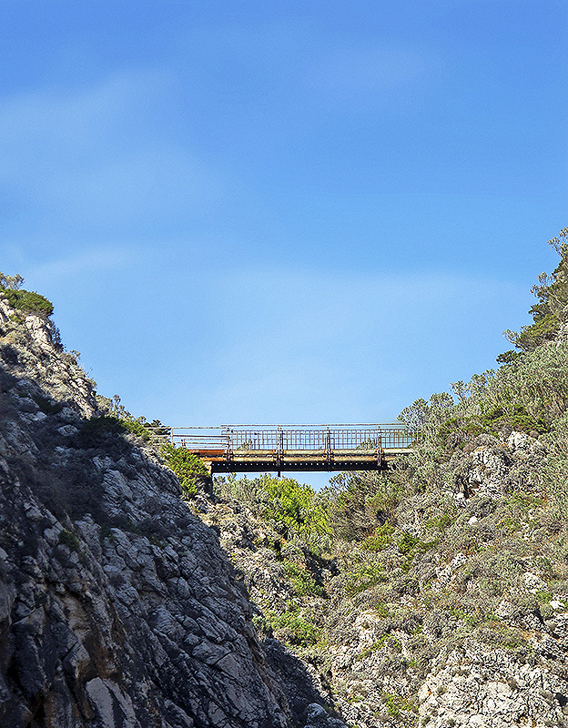
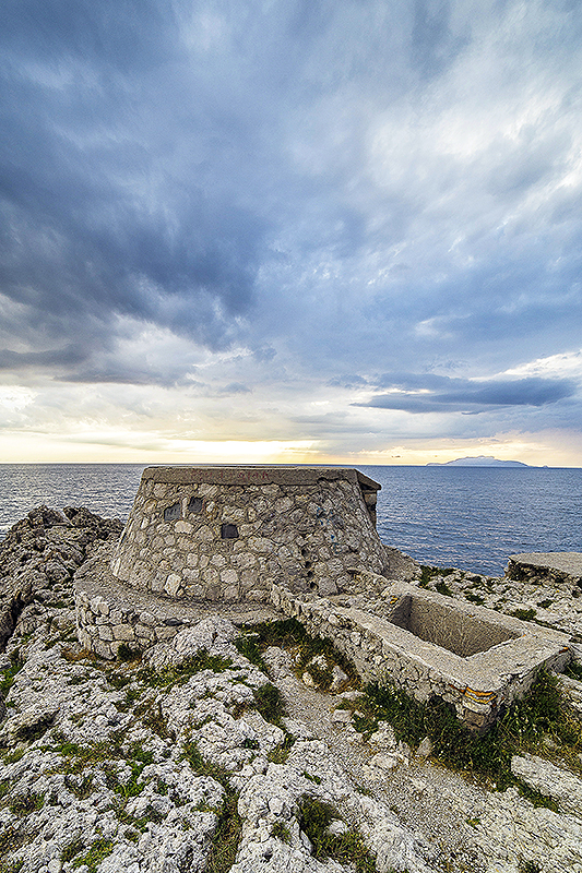
Proprio ai piedi del fortino si trova una piccola insenatura con una comoda discesa a mare, ideale per un tuffo rinfrescante prima dell’ultimo tratto dell’itinerario, che dopo una gola che somiglia a un fiordo, con un ponticello sospeso sul Rio la Rosola porta a Cala di Mezzo e, successivamente, verso il Fortino di Pino, l’ultimo dei tre principali, se non si considera quello cosiddetto “del Cannone”, più piccolo, che affaccia su Cala del Limmo.
Da qui si può concludere l’escursione, immettendosi sulla strada principale che conduce al Faro di Punta Carena, un luogo di grande bellezza, dove il tramonto mozzafiato può essere la ricompensa del più faticoso dei cammini, prima di ritornare nel centro di Anacapri comodamente in autobus o in taxi.
Mattonelle che raccontano
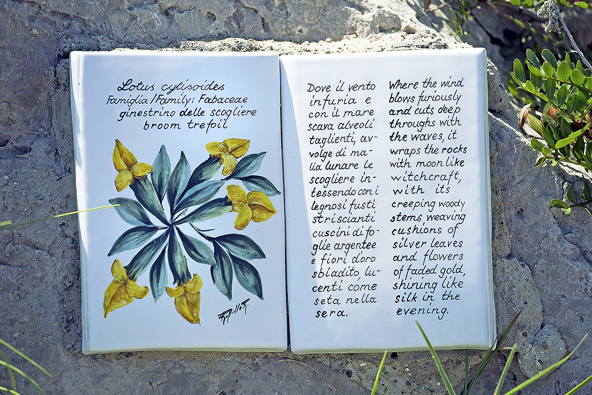
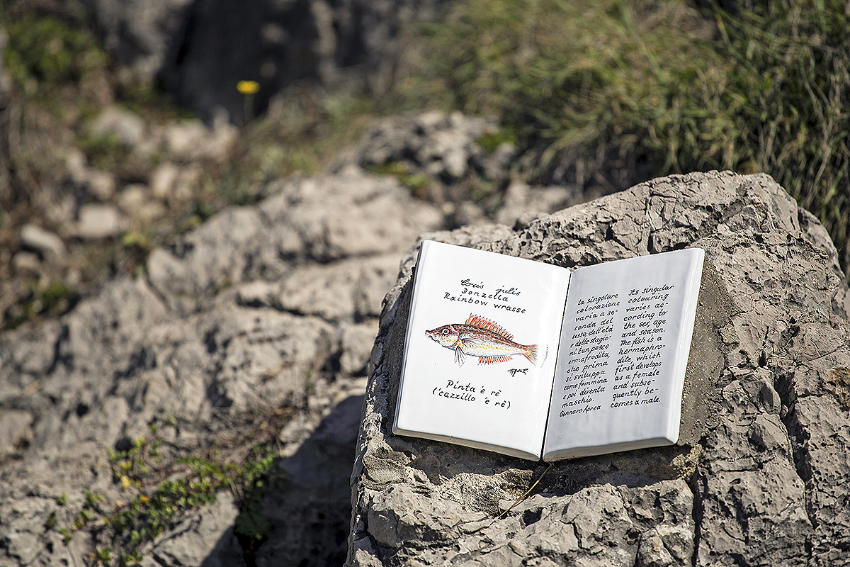 Un motivo per guardarsi bene attorno lungo il sentiero dei Fortini sono le decine di mattonelle di ceramica decorata, disseminate per il percorso, che illustrano la storia, la toponomastica e le specie di flora e fauna che caratterizzano questo tratto di costa anacaprese.
Le maioliche, a forma di libro o di più tradizionale piastrella, prodotte e decorate dal maestro ceramista Sergio Rubino, artista anacaprese, si avvalgono dei testi della naturalista e scrittrice Tullia Rizzotti e dello zoologo Gennaro Aprea per quanto riguarda rispettivamente la parte botanica, geologica e storica e quella faunistica. | Tiles that tell a story.A good reason to look around you as you walk along the Trail of the Forts is to see the many decorated ceramic tiles at different points along the route, illustrating the history, toponymy, and flora and fauna that are typical of this stretch of the Anacapri coast.
The majolica tiles, in the shape of books or the more traditional floor tiles were made and decorated by Anacapri artist and master ceramicist Sergio Rubino, and draw on texts by the naturalist and writer Tullia Rizzotti as regards the botanical, geological and historical aspects, and zoologist Gennaro Aprea as regards the fauna.
1808
 La Presa di Capri è sicuramente il più importante evento bellico, fortunatamente uno dei pochi, che hanno avuto come teatro l’isola e, in particolare, la zona dei fortini. Nel 1806 le truppe inglesi, subito dopo la caduta dei Borbone, loro alleati, avevano conquistato l’isola, sottraendola ad una guarnigione di soldati francesi che la occupava. Per due anni Capri rappresentò una spina nel fianco dei francesi, un pericoloso avamposto dei nemici inglesi. Una situazione che il re Giuseppe Bonaparte cercò senza successo di risolvere, con gli inglesi che intanto avevano fortificato alcune zone (fra cui quella dei fortini appunto) tanto che l’isola si guadagnò l’appellativo di “Piccola Gibilterra”.
Quando nel 1808 al trono di Napoli salì Gioacchino Murat, questi mise in cima alle sue priorità quella di conquistare Capri.
Addirittura erano ancora in corso i festeggiamenti per la sua salita al trono, cosa che fece passare alquanto inosservati i preparativi per l’attacco, quando affidò la missione al generale Lamarque che con le sue truppe mise a segno un vero e proprio capolavoro di strategia militare. Nella notte del 4 ottobre 1808 la flotta francese composta da 60 navi da trasporto, una fregata, una corvetta e 26 cannoniere, con un’astuta tattica diversiva trasse in inganno il colonnello Hudson Lowe, governatore militare dell’isola che attendeva l’assalto nelle zone più plausibili, ovvero quella di Marina Grande a Capri o Punta Carena ad Anacapri, dove si erano concentrate le prime manovre a distanza dei francesi. A sorpresa, buona parte della flotta francese sbarcò invece nella zona di Orrico.
La brillante manovra degli assalitori e alcuni tentennamenti del comando inglese fecero sì che in poco tempo le avanguardie prendessero il controllo della zona, spianando la strada al restante esercito che dopo numerose e sanguinose schermaglie in varie parti dell’isola, ne prese possesso. La resa inglese fu firmata il 17 ottobre.
Un episodio dalla vasta eco, riportato addirittura sull’Arco di Trionfo di Parigi, i cui personaggi, di ambo le parti, ancora oggi rimangono ben impressi nell’immaginario collettivo dell’isola e nel suo patrimonio storiografico. | The Capture of Capri is definitely the most important warfare event, fortunately one of very few, to take place on the island, more specifically, in the Fort area. In 1806 the British troops had conquered the island immediately after the fall of their allies, the Bourbons, taking it from a garrison of French soldiers that were occupying it. For two years, Capri was a thorn in the side of the French, a dangerous outpost of the British enemy forces. It was a situation that King Joseph Bonaparte tried unsuccessfully to resolve, while the British had in the mean time fortified some areas (including the area of the forts, obviously) so that the island earned the nickname of “Little Gibraltar”.
When Joachim Murat acceded to the throne in 1808, he made the conquest of Capri his top priority.
Indeed, the celebrations for his accession to the throne were still underway, which meant that the preparations for the attack passed almost unobserved when he entrusted the mission to General Lamarque, who went on to accomplish a real master stroke of military strategy with his troops. On the night of 4 October 1808, the French fleet, consisting of 60 transport ships, a frigate, a corvette and 26 gunboats, used an astute diversionary tactic to trick Colonel Hudson Lowe, the military governor of the island, who was expecting the attack in one of the more likely areas, such as Marina Grande in Capri or Punta Carena in Anacapri, where the first French manoeuvres had taken place at a distance. Instead, a large part of the French fleet made a surprise landing in the Orrico area.
The brilliant manoeuvring of the assailants and some dithering by the British command meant that the vanguard rapidly took control of the area, smoothing the way for the rest of the army, who, after several bloody skirmishes in various parts of the island, took possession of it.
The British surrender was signed on 17 October.
It was an episode that caused a huge stir – it is even represented on the Arc de Triomphe, in fact – and the participants on both sides remain strongly imprinted on the island’s collective imagination and its historiographical heritage today.
Trail of the Forts
A trail of rare beauty offering views of turquoise bays framed by rocky cliffs
by Ugo Canfora | photos by Vincenzo Gargiulo
 The Sentiero dei Fortini (Trail of the Forts), winds its way along the west coast of the island, the coast of Anacapri that stands out in sharp definition against the infinite expanse of open sea; it is one of the few parts of the island without a reassuring view of the mainland, which can always be seen from the eastern side. It is a route that embodies and encapsulates the essence of the island, with all its harsh and gentle features, through the three primeval elements that shape it: the surrounding, all-encompassing blue sea, the dolomitic rock that, in the space of a few kilometres, reveals itself as welcoming and pitiless at the same time, and the green of the Mediterranean scrub that adorns hills and rocks.
These primordial elements, like a sculptor’s raw material, have given form to and become the substance of the legend of Capri, an insignificant rock of unprecedented beauty that has held the balance of history, from ancient classical times to our own days. A history that chose those coasts to be the stage for some of its caprices: the medieval fortifications, the ‘Fortini’ in fact, kept watch for centuries, with varying success, for Saracen invasions, and have been destroyed, re-built and enlarged until, in the early 19th century, they became the defensive bastion for the British forces in the Gulf of Naples, and the scene of the “Capture of Capri” by the French army of Joachim Murat.
But for every big history, there’s also a little history: the history whispered to those who venture along the paths, rocks and walls corroded by the elements.
The trail lasts for a minimum of 3-5 hours and you can set off from two different locations: one from the Grotta Azzurra side and the other from the lighthouse at Punta Carena. If you start from the latter, you have a definite advantage in terms of ease, since you avoid the long steep climbs, while starting from the Grotta side gives the feeling of a “crescendo” that culminates with a well-deserved rest at the bay by the lighthouse at Punta Carena, from where you can admire the most beautiful sunset on the island.
The trail is not particularly difficult and it is fascinating at any time of year, obviously wearing the right clothing and suitable footwear, and taking plenty of water with you, especially in summer when the high temperatures and exposure to the sun can be a problem.
Starting at the entrance to the path just a few hundred metres from the Grotta Azzurra, near Punta dell’Arcera, after a short walk you come to the Fortino di Orrico, built on Punta del Miglio. It’s a stretch of coast high above the sea, fascinating both in the summer heat of August and in the face of the autumnal north winds, and it was here that the French troops landed, leading to the Capture of Capri. Looking out from the walls of the fort, you can see, not without some amazement, the cliff where the operations for moving the troops and logistical equipment took place. It’s difficult to imagine an easy way up that cliff, which is another reason why this manoeuvre by Murat’s army may be considered a little masterpiece of military tactics.
Continuing along the trail, dotted with illustrative ceramic tiles providing information about the species of flora and fauna typical of the area, you come to a deviation in the path that leads to a rock called the Spiaggia delle Capre (Beach of the She-Goats). After returning to the main path, there is a sharp change of scenery, as the walk continues through a sequence of different wooded areas, until, having passed the Cala del Rio, you see in the distance the second fort, Mesola, standing out from Punta Campetiello.
Right at the foot of the fort, you’ll see a small inlet where there is an easy walk down to the sea, perfect for a refreshing dip before the last section of the route. The last part leads over a gorge that looks like a fjord, with a small bridge suspended over the Rosola stream, to Cala di Mezzo and then on to the Fortino del Pino (Fort of the Pine tree), the last of the three main forts if you don’t count the so-called “Fort of the Cannon”, a smaller one that overlooks the Cala del Limmo.
From here you can end your excursion by joining the main road that leads to the lighthouse at Punta Carena, a place of great beauty, where the breathtaking sunset is a reward for what is the more tiring of the walks, before returning to the centre of Anacapri in the comfort of a bus or taxi.